
Saint Martin’s Island seems to float in the Bay of Bengal and it has importance in aspects of geographical condition, international policy, marine resources collection, and protection of the country. The unique biodiversity of Saint Martin's Island attracts numerous researchers and tourists alike, eager to explore its rich ecosystem. The present study was conducted for the determination of vegetation degradation and its impact on carbon storage of the unique Island in Bangladesh. Data were collected through the ArcGIS software, Land Use and Land Cover, Normalized Difference Vegetation Index, and InVEST model. The findings indicated that the built-up area, and cropland area increased 11.66% and 9.16% respectively from 1990 to 2020. The maximum built up area increased from 2010 to 2020. On the other hand, the aquatic land area, vegetation area, and barren land area decreased 0.032%, 13.57%, and 6.93% respectively from 1990 to 2020. The total carbon storage was 6.97×10⁴, 6.05×10⁴, 5.60×10⁴, and 5.09×10⁴ (Mg) in 1990, 2000, 2010, and 2020 respectively. The total carbon decreased 0.92×10⁴, 0.45×10⁴, and 0.51×10⁴ (Mg) from 1990 to 2020, and the highest decreased between 1990 and 2000. The findings revealed that vegetation and carbon storage declined at a geometrical rate due to infrastructural development and over tourism activities, which lead to loss of biodiversity in Saint Martin’s Island. The authority should promote ecotourism-based activities and ban all commercial tourisms. Conservation strategy, coastal zone management, and impact assessment monitoring will also be developed for the protection of the unique Island of Bangladesh.
| Published in | American Journal of Remote Sensing (Volume 14, Issue 2) |
| DOI | 10.11648/j.ajrs.20261402.19 |
| Page(s) | 152-164 |
| Creative Commons |
This is an Open Access article, distributed under the terms of the Creative Commons Attribution 4.0 International License (http://creativecommons.org/licenses/by/4.0/), which permits unrestricted use, distribution and reproduction in any medium or format, provided the original work is properly cited. |
| Copyright |
Copyright © The Author(s), 2026. Published by Science Publishing Group |
Biodiversity, Climate Change, Degradation, Endangered Species, Habitat
Date of data obtained | Sensor | Cloud Cover | Path/Row |
|---|---|---|---|
01/01/1990-12/31/1990 | Landsat 4–5 TM Collection 2 Level 2 | <5% | 136/043 |
01/01/2000-12/31/2000 | Landsat 4–5 TM Collection 2 Level 2 | <5% | 137/043 |
01/01/2010-12/31/2010 | Landsat 4–5 TM Collection 2 Level 2 | <5% | 136/043 |
01/01/2020-12/31/2020 | Landsat 8OLI/TIRS Collection 2 Level 2 | <5% | 136/043 |
LULC type | Nature of land | Indicators |
|---|---|---|
Water body | Different types of aquatic area such as rivers, canals, lakes, ponds permanent stagnant water etc. | Blue (0.015) |
Build up Area | Residential, commercial, rural settlements, industrial infrastructure, transportation related infrastructure etc. | Red (0.14) |
Barren land | Open space, bare land, exposed soil etc. | Yellowish (.018) |
Low vegetation | Crop land, shrubs, playgrounds etc. | Light green (0.27) |
Medium vegetation | Less tree than dense vegetation area | Medium green (0.36) |
Dense vegetation | Trees and mixed forestland | Very green (>0.36) |
LULC class | Carbon density ton per square kilometer (t/km2) | References | |||
|---|---|---|---|---|---|
Ca | Cb | Cs | Cd | ||
Water body | 0 | 0 | 11900 | 123 | [32] |
Vegetation land | 410 | 5640 | 22600 | 22 | [33] |
Built up | 210 | 4510 | 11530 | 27 | [34] |
Crop land | 4650 | 8070 | 10840 | 100 | [35] |
Bare land | 2260 | 9030 | 14660 | 294 | [30] |
LULC types | 1990 | 2000 | 2010 | 2020 |
|---|---|---|---|---|
Carbon storage (Mg) | Carbon storage (Mg) | Carbon storage (Mg) | Carbon storage (Mg) | |
Aquatic area | 0.04×10⁴ | 0.02×10⁴ | 0.05×10⁴ | 0.02×10⁴ |
Vegetation | 3.90×10⁴ | 3.02×10⁴ | 2.65×10⁴ | 2.12×10⁴ |
Built up area | 1.43×10⁴ | 1.59×10⁴ | 1.69×10⁴ | 1.85×10⁴ |
Crop land area | 1.39×10⁴ | 1.31×10⁴ | 1.12×10⁴ | 1.03×10⁴ |
Barren land area | 0.21×10⁴ | 0.11×10⁴ | 0.09×10⁴ | 0.07×10⁴ |
Total CS | 6.97×10⁴ | 6.05×10⁴ | 5.60×10⁴ | 5.09×10⁴ |
GEE | Google Earth Engine |
InVEST | Integrated Valuation of Ecosystem Services and Tradeoffs |
LCM | Land Change Modeler |
LULC | Land Use and Land Cover |
NDVI | Normalized Difference Vegetation Index |
NIR | Near-Infrared |
OLI | Operational Land Imager |
TIRS | Thermal Infrared Sensor |
TM | Thematic Mapper |
UNDP | United Nations Development Programme |
WGS-84 | World Geodetic System 1984 |
CS | Carbon Storage (used in “Total CS” in Table 4) |
Mg | Megagram (metric tonne; 1 Mg = 1,000 kg) |
t/ha | Metric Tonnes per Hectare |
t/km2 | Metric Tonnes per Square Kilometer |
Ca (Ca) | Carbon Stock in Aboveground Biomass |
Cβ (Cb) | Carbon Stock in Belowground Biomass |
Cs (Cs) | Carbon Stock in Soil Organic Carbon |
Cd (Cd) | Carbon Stock in Dead Organic Matter |
Am (Am) | Area of Land-use/land-cover Class m (as used in the carbon-stock equation) |
| [1] | Jahan, S., Quamruzzaman, J. M. Land use planning for development of environmentally sensitive areas: Case study of St. Martin’s Island, Bangladesh. Studies in Regional Science. 2010, 40(4), 1079–1092. |
| [2] | Tomascik, T., Chowdhury, M. S. N., Bell, T. Comment on Gazi et al. (2020): Detecting coral reef degradation on St. Martin’s Island, Bangladesh? Ocean Science Journal. 2021, 56(3), 326–329. |
| [3] |
Bay of Bengal Large Marine Ecosystem (BOBLME) Project. Socio-economic monitoring report for St. Martin’s Island, Bangladesh. 2015.
https://www.boblme.org/documentRepository/BOBLME-2015-Socioec-06.pdf |
| [4] | Hossain, M. M., Islam, M. H. Status of the biodiversity of St. Martin’s Island, Bay of Bengal, Bangladesh. Pakistan Journal of Marine Sciences. 2006, 15(2), 201–210. |
| [5] |
Mahboob, A. S. Urgent protection measures needed for Bangladesh’s only coral island. United Nations Development Programme Bangladesh. 2023.
https://www.undp.org/bangladesh/blog/urgent-protection-measures-needed-bangladeshs-only-coral-island |
| [6] | Rahman, M. M. Present status of plant diversity in Saint Martin’s Island of Bangladesh. International Journal of Advances in Engineering and Management. 2022, 4(8), 823–829. |
| [7] | Al Nahian, S., Rakib, M. R. J., Haider, S. M. B., Kumar, R., Walker, T. R., Khandaker, M. U., Idris, A. M. Baseline marine litter abundance and distribution on Saint Martin Island, Bay of Bengal, Bangladesh. Marine Pollution Bulletin. 2022, 183, 114091. |
| [8] | Hossen, M. F., Sultana, N. Landscape transition-induced ecological risk modeling using GIS and remote sensing techniques: A case of Saint Martin Island, Bangladesh. Environmental Monitoring and Assessment. 2024, 196(10), 964. |
| [9] | Biswas, J., Malaker, T., Mollick, T. Tourism and environmental change in Saint Martin Island, Bangladesh: Insights from remote sensing data. Remote Sensing Applications: Society and Environment. 2025, 37, 101484. |
| [10] | Kayum, S., Shimatani, Y., Minagawa, T. Evaluation of Pandanus trees as a means of ecosystem-based disaster risk reduction against storm-surge waves on Saint Martin’s Island, Bangladesh. Water. 2022, 14(11), 1781. |
| [11] | Roy, B. Assessment of vegetation health in Saint Martin’s Island, Bangladesh, using remote sensing and GIS. International Journal of Innovations in Engineering Research and Technology. 2020, 7(7), 89–93. |
| [12] | Hassan, M., Islam, M. M., Hoda, M. N., Pia, H., Aktar, M., Rahman, A., Hassan, M. A., Palit, A. K., Mohonto, R., Al Faysal, J., Uddin, M. J. Investigating the soil carbon storage dynamic and sequestration potentiality in the tropical coral island (St. Martin) of Bay of Bengal. Asian Journal of Environment & Ecology. 2018, 6(1), 1–9. |
| [13] | Natural Capital Alliance. InVEST User Guide, version 3.20.2: Carbon Storage and Sequestration model. 2026. |
| [14] | Alam, O., Deng, T. L., Uddin, M. N., Alamgir, M. Application of environmental ethics for sustainable development and conservation of Saint Martin’s Island in Bangladesh. Journal of Environmental Science and Natural Resources. 2015, 8(1), 19–27. |
| [15] | Thompson, P. M., Islam, M. A. (Eds.). Environmental profile of St. Martin’s Island. United Nations Development Programme Bangladesh. 2010. |
| [16] | Alam, M. J., Kamal, A. S. M., Ahmed, M. K., Rahman, M., Hasan, M., Rahman, S. A. R. Nutrient and heavy metal dynamics in the coastal waters of St. Martin’s Island in the Bay of Bengal. Heliyon. 2023, 9(10), e20458. |
| [17] | Hossain, M. S., Chowdhury, S. R., Rashed-Un-Nabi, M. Resource mapping of Saint Martin’s Island using satellite image and ground observations. Journal of Forestry & Environment. 2007, 5, 23–36. |
| [18] | Gorelick, N., Hancher, M., Dixon, M., Ilyushchenko, S., Thau, D., Moore, R. Google Earth Engine: Planetary-scale geospatial analysis for everyone. Remote Sensing of Environment. 2017, 202, 18–27. |
| [19] | Nasiri, V., Deljouei, A., Moradi, F., Sadeghi, S. M. M., Borz, S. A. Land use and land cover mapping using Sentinel-2, Landsat-8 satellite images, and Google Earth Engine: A comparison of two composition methods. Remote Sensing. 2022, 14(9), 1977. |
| [20] | Rahaman, S. N., Shehzad, T., Sultana, M. Effect of seasonal land surface temperature variation on COVID-19 infection rate: A Google Earth Engine-based remote sensing approach. Environmental Health Insights. 2022, 16. |
| [21] | Rahaman, S. N., Shermin, N. Identifying the effect of monsoon floods on vegetation and land surface temperature by using Google Earth Engine. Urban Climate. 2022, 43, 101162. |
| [22] | Rahaman, S. N., Ahmed, S. M. M., Zeyad, M., Zim, A. H. Effect of vegetation and land surface temperature on NO₂ concentration: A Google Earth Engine-based remote sensing approach. Urban Climate. 2023, 47, 101336. |
| [23] |
U.S. Geological Survey. What are the band designations for the Landsat satellites? USGS FAQ.
https://www.usgs.gov/faqs/what-are-band-designations-landsat-satellites |
| [24] | Tucker, C. J. Red and photographic infrared linear combinations for monitoring vegetation. Remote Sensing of Environment. 1979, 8(2), 127–150. |
| [25] | Tassi, A., Vizzari, M. Object-oriented LULC classification in Google Earth Engine combining SNIC, GLCM, and machine learning algorithms. Remote Sensing. 2020, 12(22), 3776. |
| [26] | Pan, X., Wang, Z., Gao, Y., Dang, X., Han, Y. Detailed and automated classification of land use/land cover using machine learning algorithms in Google Earth Engine. Geocarto International. 2022, 37, 5415–5432. |
| [27] | Iban, M. C., Sahin, E. Monitoring land use and land cover change near a nuclear power plant construction site: Akkuyu case, Turkey. Environmental Monitoring and Assessment. 2022, 194, 724. |
| [28] | Eastman, J. R., Toledano, J. A short presentation of the Land Change Modeler (LCM). In: Camacho Olmedo, M. T., Paegelow, M., Mas, J. F., Escobar, F. (Eds.), Geomatic Approaches for Modeling Land Change Scenarios. Springer, Cham. 2018, 499–505. |
| [29] | Hoque, M. Z., Cui, S., Islam, I., Xu, L., Ding, S. Dynamics of plantation forest development and ecosystem carbon storage change in coastal Bangladesh. Ecological Indicators. 2021, 130, 107954. |
| [30] | Liang, Y., Hashimoto, S., Liu, L. Integrated assessment of land-use/land-cover dynamics on carbon storage services in the Loess Plateau of China from 1995 to 2050. Ecological Indicators. 2021, 120, 106939. |
| [31] | Aalde, H., Gonzalez, P., Gytarsky, M., Krug, T., Kurz, W. A., Lasco, R. D., Martino, D. L., McConkey, B. G., Ogle, S., Paustian, K. Generic methodologies applicable to multiple land-use categories. In: Eggleston, S., Buendia, L., Miwa, K., Ngara, T., Tanabe, K. (Eds.), 2006 IPCC Guidelines for National Greenhouse Gas Inventories, Volume 4. Institute for Global Environmental Strategies. 2006, Chapter 2, pp. 2.1–2.59. |
| [32] | Ma, T., Li, X., Bai, J., Ding, S., Zhou, F., Cui, B. Four decades’ dynamics of coastal blue carbon storage driven by land use/land cover transformation under natural and anthropogenic processes in the Yellow River Delta, China. Science of the Total Environment. 2019, 655, 741–750. |
| [33] | Li, K. R., Wang, S. Q., Cao, M. K. Vegetation and soil carbon storage in China. Science in China Series D: Earth Sciences. 2004, 47(1), 49–57. |
| [34] | Adelisardou, F., Zhao, W., Chow, R., Mederly, P., Minkina, T., Schou, J. S. Spatiotemporal change detection of carbon storage and sequestration in an arid ecosystem by integrating Google Earth Engine and InVEST (the Jiroft plain, Iran). International Journal of Environmental Science and Technology. 2022, 19, 5929–5944. |
| [35] | Kafy, A. A., Saha, M., Fattah, M. A., Rahman, M. T., Duti, B. M., Rahaman, Z. A., Bakshi, A., Kalaivani, S., Rahaman, S. N., Sattar, G. S. Integrating forest cover change and carbon storage dynamics: Leveraging Google Earth Engine and InVEST model to inform conservation in hilly regions. Ecological Indicators. 2023, 152, 110374. |
| [36] | Ara, S., Alif, M. A. U. J., Islam, K. M. A. Impact of tourism on LULC and LST in a coastal island of Bangladesh: A geospatial approach on St. Martin’s Island of Bay of Bengal. Journal of the Indian Society of Remote Sensing. 2021, 49(10), 2329–2345. |
| [37] | Hassan, M. M., Smith, A. C., Walker, K., Rahman, M. K., Southworth, J. Rohingya refugee crisis and forest cover change in Teknaf, Bangladesh. Remote Sensing. 2018, 10(5), 689. |
| [38] | Solomon, N., Pabi, O., Annang, T., Asante, I. K., Birhane, E. The effects of land cover change on carbon stock dynamics in a dry Afromontane forest in northern Ethiopia. Carbon Balance and Management. 2018, 13, 14. |
| [39] | Ali, A., Yan, E. R., Chen, H. Y. H., Chang, S. X., Zhao, Y. T., Yang, X. D., Xu, M. S. Stand structural diversity rather than species diversity enhances aboveground carbon storage in secondary subtropical forests in Eastern China. Biogeosciences. 2016, 13, 4627–4635. |
| [40] | Shen, C., Ma, L., Hu, J., Huang, L., Chen, Y., Guan, D. Soil carbon storage and its determinants in forest fragments of differentiated patch size. Forests. 2019, 10(11), 1044. |
| [41] | Sha, Z., Bai, Y., Li, R., Lan, H., Zhang, X., Li, J., Liu, X., Chang, S., Xie, Y. The global carbon sink potential of terrestrial vegetation can be increased substantially by optimal land management. Communications Earth & Environment. 2022, 3, 8. |
APA Style
Rahman, M. M., Naz, S., Hamid, N., Rahman, M. R. (2026). Changing Patterns of Vegetation and Its Impact on Carbon Sequestration in Saint Martin’s Island from 1990 to 2020. American Journal of Remote Sensing, 14(2), 152-164. https://doi.org/10.11648/j.ajrs.20261402.19
ACS Style
Rahman, M. M.; Naz, S.; Hamid, N.; Rahman, M. R. Changing Patterns of Vegetation and Its Impact on Carbon Sequestration in Saint Martin’s Island from 1990 to 2020. Am. J. Remote Sens. 2026, 14(2), 152-164. doi: 10.11648/j.ajrs.20261402.19
@article{10.11648/j.ajrs.20261402.19,
  author = {Mohammed Mukhlesur Rahman and Sabrina Naz and Nurul Hamid and Md. Redwanur Rahman},
  title = {Changing Patterns of Vegetation and Its Impact on Carbon Sequestration in Saint Martin’s Island from 1990 to 2020},
  journal = {American Journal of Remote Sensing},
  volume = {14},
  number = {2},
  pages = {152-164},
  doi = {10.11648/j.ajrs.20261402.19},
  url = {https://doi.org/10.11648/j.ajrs.20261402.19},
  eprint = {https://article.sciencepublishinggroup.com/pdf/10.11648.j.ajrs.20261402.19},
  abstract = {Saint Martin’s Island seems to float in the Bay of Bengal and it has importance in aspects of geographical condition, international policy, marine resources collection, and protection of the country. The unique biodiversity of Saint Martin's Island attracts numerous researchers and tourists alike, eager to explore its rich ecosystem. The present study was conducted for the determination of vegetation degradation and its impact on carbon storage of the unique Island in Bangladesh. Data were collected through the ArcGIS software, Land Use and Land Cover, Normalized Difference Vegetation Index, and InVEST model. The findings indicated that the built-up area, and cropland area increased 11.66% and 9.16% respectively from 1990 to 2020. The maximum built up area increased from 2010 to 2020. On the other hand, the aquatic land area, vegetation area, and barren land area decreased 0.032%, 13.57%, and 6.93% respectively from 1990 to 2020. The total carbon storage was 6.97×10⁴, 6.05×10⁴, 5.60×10⁴, and 5.09×10⁴ (Mg) in 1990, 2000, 2010, and 2020 respectively. The total carbon decreased 0.92×10⁴, 0.45×10⁴, and 0.51×10⁴ (Mg) from 1990 to 2020, and the highest decreased between 1990 and 2000. The findings revealed that vegetation and carbon storage declined at a geometrical rate due to infrastructural development and over tourism activities, which lead to loss of biodiversity in Saint Martin’s Island. The authority should promote ecotourism-based activities and ban all commercial tourisms. Conservation strategy, coastal zone management, and impact assessment monitoring will also be developed for the protection of the unique Island of Bangladesh.},
 year = {2026}
}
TY  - JOUR
T1  - Changing Patterns of Vegetation and Its Impact on Carbon Sequestration in Saint Martin’s Island from 1990 to 2020
AU  - Mohammed Mukhlesur Rahman
AU  - Sabrina Naz
AU  - Nurul Hamid
AU  - Md. Redwanur Rahman
Y1  - 2026/11/16
PY  - 2026
N1  - https://doi.org/10.11648/j.ajrs.20261402.19
DO  - 10.11648/j.ajrs.20261402.19
T2  - American Journal of Remote Sensing
JF  - American Journal of Remote Sensing
JO  - American Journal of Remote Sensing
SP  - 152
EP  - 164
PB  - Science Publishing Group
SN  - 2328-580X
UR  - https://doi.org/10.11648/j.ajrs.20261402.19
AB  - Saint Martin’s Island seems to float in the Bay of Bengal and it has importance in aspects of geographical condition, international policy, marine resources collection, and protection of the country. The unique biodiversity of Saint Martin's Island attracts numerous researchers and tourists alike, eager to explore its rich ecosystem. The present study was conducted for the determination of vegetation degradation and its impact on carbon storage of the unique Island in Bangladesh. Data were collected through the ArcGIS software, Land Use and Land Cover, Normalized Difference Vegetation Index, and InVEST model. The findings indicated that the built-up area, and cropland area increased 11.66% and 9.16% respectively from 1990 to 2020. The maximum built up area increased from 2010 to 2020. On the other hand, the aquatic land area, vegetation area, and barren land area decreased 0.032%, 13.57%, and 6.93% respectively from 1990 to 2020. The total carbon storage was 6.97×10⁴, 6.05×10⁴, 5.60×10⁴, and 5.09×10⁴ (Mg) in 1990, 2000, 2010, and 2020 respectively. The total carbon decreased 0.92×10⁴, 0.45×10⁴, and 0.51×10⁴ (Mg) from 1990 to 2020, and the highest decreased between 1990 and 2000. The findings revealed that vegetation and carbon storage declined at a geometrical rate due to infrastructural development and over tourism activities, which lead to loss of biodiversity in Saint Martin’s Island. The authority should promote ecotourism-based activities and ban all commercial tourisms. Conservation strategy, coastal zone management, and impact assessment monitoring will also be developed for the protection of the unique Island of Bangladesh.
VL  - 14
IS  - 2
ER  -
Institute of Environmental Science, University of Rajshahi, Rajshahi, Bangladesh
Biography: Mohammed Mukhlesur Rahman holds Botany degrees from the University of Chittagong (B.Sc. Honours, 1996; M.Sc., 1997). After medical promotion and Botany teaching, he joined the Bangladesh Forest Research Institute in 2007 and became a Research Officer in 2020. He earned an M.Phil. (2012) and Ph.D. (2020) from Jahangirnagar University and completed a postdoctoral fellowship at the University of Rajshahi. His research focuses on forest carbon storage, forest-resource management, and climate-change mitigation. He has published about 40 papers and reviews, authored books and chapters, supervised postgraduate students, served as a journal sub-editor, and holds life memberships in scientific societies.

Department of Botany, University of Rajshahi, Rajshahi, Bangladesh
Biography: Sabrina Naz is a Professor and Head of the department of Botany, University of Rajshahi, Bangladesh. She received her Ph. D. in Limnology and Phycology. She also holds master's and bachelor's degrees in Botany from the University of Rajshahi, Bangladesh. Her research interests include wet land and coastal environments, climate-change vulnerability, and disaster-risk assessment. She has extensive experience in teaching, postgraduate research supervision, and multidisciplinary environmental and geospatial research, with numerous journal articles, book chapters and funded research projects focusing particularly on the coastal and environmentally vulnerable regions of Bangladesh.

Institute of Environmental Science, University of Rajshahi, Rajshahi, Bangladesh
Biography: Nurul Hamid is an Assistant Professor in the Botany Discipline under the Ministry of Education, Government of Bangladesh, and currently a PhD Fellow at the Institute of Environmental Science (IES), University of Rajshahi, Bangladesh. His research expertise lies in ecology, biodiversity conservation, and geospatial science, with a strong focus on understanding ecosystem dynamics and environmental change. His research integrates spatial ecological modelling to assess biodiversity patterns and ecosystem changes. Through interdisciplinary ecological and geospatial approaches, his work supports evidence-based conservation, sustainable resource management, and informed environmental policy development. He is committed to advancing biodiversity research and ecosystem conservation under changing environmental conditions.

Institute of Environmental Science, University of Rajshahi, Rajshahi, Bangladesh
Biography: Md. Redwanur Rahman is a Professor and an academic researcher at the Institute of Environmental Science, University of Rajshahi, Bangladesh. His research interests include ecology, biodiversity, aquatic ecosystems, environmental change, and sustainable natural resource management. His research particularly focuses on molluscan biodiversity, aquatic food systems, environmental pollution, microplastics, and the impacts of human activities on ecosystems. He also investigates species interactions, ecosystem functioning, and the effects of environmental and climatic changes on biodiversity. Through field-based ecological studies and laboratory analyses, his research contributes to a better understanding and sustainable management of aquatic and terrestrial ecosystems.

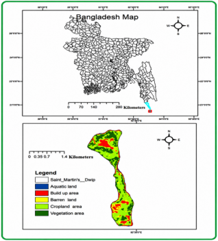
Figure 1. Geographic location and Land Use/Land Cover (LULC) classification map of Saint Martin’s Island, Bangladesh.
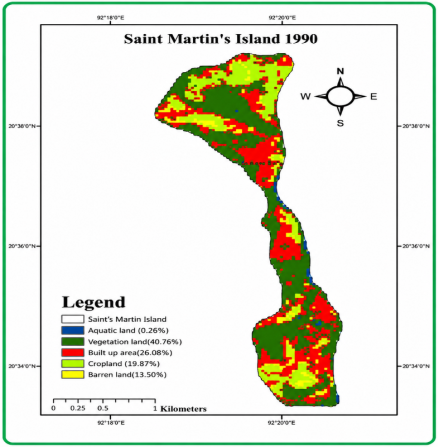
Figure 2. Spatial distribution of Land Use and Land Cover (LULC) classes across Saint Martin's Island in 1990.
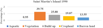
Figure 3. Land cover patterns of Saint Martin's Island in 1990.
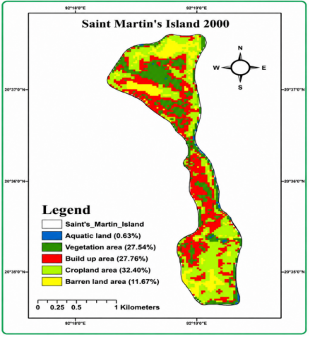
Figure 4. Land Use/Land Cover (LULC) map of Saint Martin's Island in the year 2000.
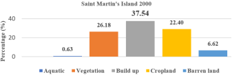
Figure 5. Land cover distribution of Saint Martin's Island in 2000. Bar chart illustrating the percentage distribution across five distinct land cover categories.
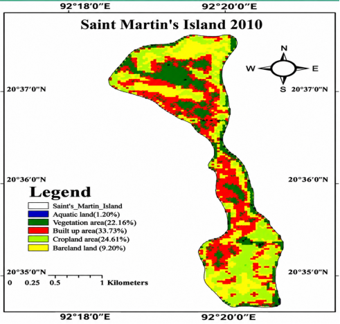
Figure 6. Land Use and Land Cover (LULC) classification map of Saint Martin's Island in 2010.
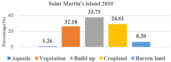
Figure 7. Quantitative distribution of Land Use and Land Cover (LULC) classes for Saint Martin's Island in 2010.
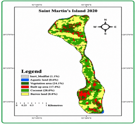
Figure 8. Land Use and Land Cover (LULC) Map of Saint Martin's Island (2020).
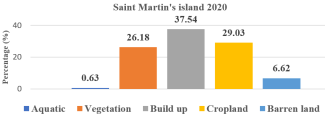
Figure 9. Land use and land cover (LULC) distribution percentage of Saint Martin’s Island in 2020.

Information



 Share This Article
 Twitter
 Linked In
 Facebook

 Copy
 Download